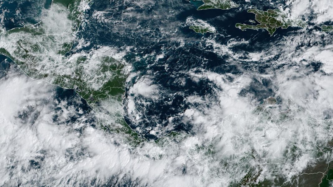
It’s November, the final month of the Atlantic hurricane season, and the active hurricane season of 2024 appears primed to deliver a November named storm — which would be named Patty — in the Western Caribbean. A sprawling low-pressure system known as a Central American Gyre, or CAG, is developing over Central America and the southwestern Caribbean, which will bring heavy rain to portions of Central America. Rainfall in excess of 10 inches (250 mm) over Panama and Costa Rica over the next week could cause dangerous flash flooding and mudslides. The gyre also has the potential to spawn a tropical storm.

The gyre — a type of monsoon low — is a weak but expansive area of surface low pressure that can persist for two weeks or more across Central America and adjacent parts of the Atlantic and Pacific, including the western Caribbean and southwest Gulf of Mexico. They are most common in May, June, September, October, and November. The gyres often spin off smaller circulations that can become full-fledged tropical cyclones, which can be weak or strong. One such circulation formed in June in the Gulf of Mexico and became the season’s first named storm, Alberto. More seriously, this year’s two catastrophic Gulf of Mexico hurricanes, Helene, and Milton, were both spawned from a CAG.


A Central American Gyre typically takes many days to organize, then once fully developed, several more days to spin off a tropical cyclone. The formation location of a tropical cyclone spun off from a Central American Gyre is very difficult to predict more than two days in advance, but our top forecast models have been persistently predicting that it will spawn the Atlantic’s next named storm – Patty – sometime in the coming week. Conditions are generally favorable for development over the region, with moderate wind shear of 10-20 knots, a moist atmosphere, and sea surface temperatures near 29 degrees Celsius (84°F), which is about 0.5-1.0 degree Celsius above average.
A strong ridge of high pressure to the north of the Caribbean will allow the developing system to drift slowly northward, potentially bringing heavy rains across Jamaica, the Cayman Islands, Cuba, and Haiti in the coming days. The system is likely to turn more to the northwest by Tuesday, which may bring it into the Gulf of Mexico by midweek.


A hostile environment in the Gulf of Mexico
If wanna-be-Patty does eventually make it into the Gulf of Mexico, it will have an environment much less favorable for development than encountered by Hurricanes Helene and Milton in September and October. Recurring fall cold fronts have spread cool air over the Gulf in recent weeks, causing significant cooling of the waters. More importantly, the jet stream has shifted more to the south and will bring high wind shear accompanied by dry air, making it difficult for a tropical cyclone in the Gulf to intensify (Fig. 3).
In its 2 p.m. EDT Friday Tropical Weather Outlook, the National Hurricane Center (NHC) gave two-day and seven-day odds of tropical cyclone development in the Western Caribbean of 30% and 70%, respectively. As of Thursday, no Hurricane Hunter missions for this system had been scheduled.


Development also possible with 96L in the remote North Atlantic
Update: Subtropical Storm Patty was named at 5 a.m. EDT Saturday, Nov. 2, and the Azores Meteorological Service has issued a Tropical Storm Warning for all the islands of the Azores.
The name Patty might also get scooped up by a non-tropical system located a few hundred miles west of the Azores in the open North Atlantic. Low pressure at the surface and aloft left behind by a departing mid-latitude trough and cold front is now largely detached from the jet stream, and shower and thunderstorm activity has slowly been emerging around this well-developed cyclone, which has been designated Invest 96L.
Subtropical Storm #Patty has formed in the eastern Atlantic – the 16th named storm of the 2024 Atlantic #hurricane season and the 9th named storm since September 24. 2024 is tied with 1950 for the most Atlantic named storm formations between 9/24-11/2 on record. pic.twitter.com/oXfUHWnBfz
— Philip Klotzbach (@philklotzbach) November 2, 2024
Sea surface temperatures around 20 degrees Celsius (68 degrees Fahrenheit) are well below the standard 26°C threshold for tropical development. Still, the cold upper low atop the lukewarm waters may provide enough instability for 96L to develop into a low- to moderate-strength subtropical storm. Top sustained winds south of 96L’s center already exceed the 40-mph threshold, according to satellite-derived wind data. Wind shear will increase dramatically from the light to moderate range (5-15 knots) to greater than 20 knots by late Saturday, which would tend to support subtropical rather than tropical development.
In its 2 p.m. EDT Friday outlook, NHC gave 40 percent odds of 96L developing into a subtropical or tropical cyclone over both the two- and seven-day periods, suggesting that any development would most likely occur over the weekend. As this cyclone moves eastward, it could affect the Azores by late in the weekend or early next week; models project it to weaken steadily around that point and thereafter as it hits much cooler waters. The next name on the Atlantic list after Patty is Rafael.
Bob Henson contributed to this post.


