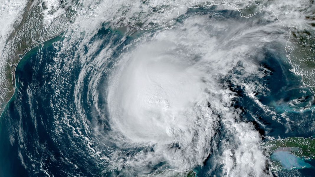
Only a handful of storms in 173 years of Atlantic hurricane records have ever roamed the Gulf of Mexico as a hurricane but then met their demise before making landfall on the Gulf Coast as tropical cyclones. Happily for Gulf Coast residents, this month’s Hurricane Rafael is on track to join that short list of eight – and it’d be the only major hurricane among them.
Rafael briefly restrengthened into a major Category 3 hurricane in the Gulf early Friday, becoming the farthest west a major hurricane has ever been recorded in November. Thankfully Rafael will stay over water though the Gulf Coast will feel its influence.https://t.co/qcGqi7VxgZ pic.twitter.com/B2StQ0nNlY
— Michael Lowry (@MichaelRLowry) November 8, 2024
As of 4 p.m. EDT Friday, Rafael was a compact Category 2 hurricane located about 500 miles (805 km) east of Brownsville, Texas, moving west at 9 mph (14 km/h). The minimum central pressure was 967 mb. Rafael’s top sustained winds were down to 100 mph (161 km/h) after peaking at 120 mph (193 km/h) early Friday, a level that had put it at Cat 3 strength and in a tie with 1985’s Hurricane Kate as the strongest Gulf hurricane ever recorded in the month of November.
Intense thunderstorms were still bubbling within Rafael late Friday, but a crisp eye was no longer evident on satellite imagery and wind shear was restricting upper-level outflow on Rafael’s west side.
There’s no lack of warm water to keep Rafael going. As of November 7, sea surface temperatures in the Gulf of Mexico were at record-warm levels for the time of year. But dry air lurking to the north and west of Rafael and high pressure building to Rafael’s west will block the storm from moving toward land while starving its showers and thunderstorms (convection) over the weekend. Midlevel relative humidity around Rafael is predicted to plunge from 45-50% on Friday afternoon to 25-30% by Monday. Over time, the dry air and wind shear will sap Rafael’s convection and compromise its structure.
In its forecast issued at 4 p.m. EST Friday, the National Hurricane Center predicted that Rafael would weaken below hurricane strength by late Saturday and would be a remnant low by Monday, drifting southward toward the Bay of Campeche. Update: As of 10 p.m. EST Friday, Rafael had already weakened dramatically to tropical storm status, with top sustained winds down to 70 mph.
Of 284 Gulf #hurricanes in NOAA’s database from 1851-2023, only 8 of them failed to make a Gulf Coast landfall as at least a T.D.
Marco (2020) was the most recent.
Looks like #Rafael will become the ninth. pic.twitter.com/rYsuLYHvEO
— Jonathan Erdman (@wxjerdman) November 8, 2024

An analog for Rafael: Hurricane Jeanne in 1980
Among the Gulf hurricanes that have failed to make landfall as tropical cyclones, the strongest was Jeanne (see Fig. 2 above). Jeanne peaked at Category 2 strength in the south central Gulf on November 11, 1980, not far from where Rafael reached its own peak intensity. Similar to Rafael’s expected track, Jeanne moved west but encountered a blocking high that stranded it well off the coast of south Texas and northeast Mexico, where it moved erratically while weakening and eventually merging with a front.
Also failing to make landfall before dissipation in the Gulf was Category 1 Hurricane Alberto (1982). The latter was an early-June storm that intensified in the Gulf just off the northwest coast of Cuba, causing devastating floods there that killed 23 people and inflicted more than $200 million in damage (2024 USD).
Much like Alberto, Rafael caused major problems for Cuba before entering the Gulf. Rafael made landfall as a Category 3 storm on the southwest coast of Cuba on Wednesday, knocking out Cuba’s national electrical grid for a day (the second such failure within the past month). Reuters reported on Friday that power remained out in the Havana area as of late Thursday, with no timeline for restoration announced.


Still watching the Caribbean and points nearby as hurricane season approaches its end
Hurricane season in the Atlantic officially ends on November 30. For the time being, though, long-range ensemble models suggest that yet another system might spin off in the Caribbean in mid-November from the recurrent Central American Gyre feature. The Caribbean remains more than warm enough to support hurricane development, with its average temperature of around 29.5 degrees Celsius (85 degrees Fahrenheit) higher than in any other year on record for November 7 except for last year, 2023. Should upper-level conditions evolve in a favorable way, any development in the Caribbean would still bear watching for regional impacts.
Jeff Masters contributed to this post.
We help millions of people understand climate change and what to do about it. Help us reach even more people like you.


