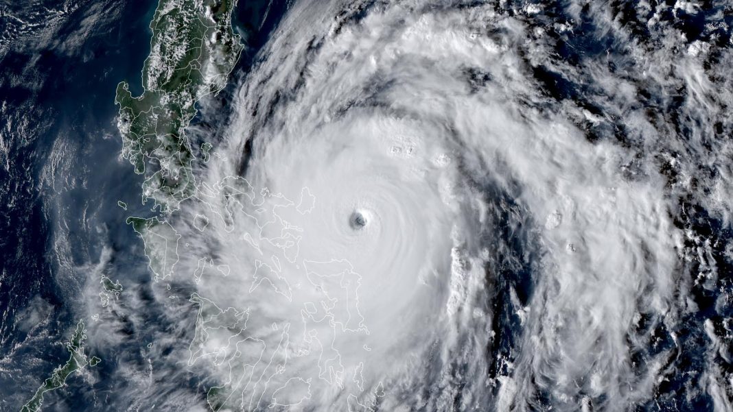
Super Typhoon Man-yi (called Pepito in the Philippines) made landfall on Catanduanes Island in the Philippines at 9:40 p.m. local time on Saturday, Nov. 16, as a category 5 storm with 160 mph winds and a central pressure of 921 mb, as determined by the Joint Typhoon Warning Center (JTWC).
The Philippines have suffered an unprecedented battering by November typhoons, with Man-yi being the fourth typhoon to hit the nation in a span of less than 10 days. The four landfalls:
- Typhoon Yinxing (Cat 4): Nov. 7
- Typhoon Toraji (Cat 1): Nov. 11
- Super Typhoon Usagi (Cat 4): Nov. 14
- Super Typhoon Man-Yi (Cat 5): Nov. 16
Even before Man-yi, the three prior landfalls this month had caused at least 160 deaths and displaced more than 9 million people, according to the Associated Press. In addition, nine other tropical storms or typhoons have caused damage or loss of life in the Philippines in 2024, according to Gallagher Re:
- Typhoon Ewiniar (landfall as a tropical storm): May 24-27: 6 killed, $20 million damage
- Typhoon Gaemi (no landfall) Jul. 24-25: Damage of $177 million
- Typhoon Shanshan (no landfall): Aug 28
- Typhoon Yagi (landfall as a tropical storm): Sep. 1-9
- Typhoon Bebinca (no landfall): Sep. 13-16
- Tropical Storm Soulik (landfall as a tropical storm): Sep 15-19
- Typhoon Krathon (no landfall): Sep. 29-30
- Tropical Storm Trami (landfall as a tropical storm): Oct. 24
- Typhoon Kong-rey (no landfall): Oct. 30
An average number of Cat 5s for 2024
Super Typhoon Man-yi is Earth’s fifth Cat 5 of the year. The other Category 5 storms were two Atlantic hurricanes, Beryl and Milton, one Western Pacific typhoon, Yagi, and one Eastern Pacific hurricane, Kristy. The strongest tropical cyclone of 2024 was Hurricane Milton, which topped out with 180 mph winds and a central pressure of 899 mb.
The 1990-2023 average globally for an entire calendar year is 5.3 Cat 5s, so we are near average this year. The record is 12 Cat 5s in a year, set in 1997. Last year had nine Cat 5s.

If one looks at the number of category 5 storms that have occurred since 1982—the year most commonly used in the scientific literature to begin the study of global tropical cyclone trends because of the global availability of high-quality satellite data — there has been a noticeable increase in Cat 5s (Fig. 1, above). A similar increase can be seen in the number of ultra-intense tropical cyclones with winds of at least 180 mph (290 km/h, Fig. 2, below).


According to a 2020 review paper by 11 hurricane scientists, “Tropical Cyclones and Climate Change Assessment: Part II: Projected Response to Anthropogenic Warming”, the proportion of global tropical cyclone that reach category 4 and 5 strength is likely to increase as the climate warms, with 8 of 11 authors rating this as medium-to-high confidence and three authors rating it as high confidence. The median projected change for a 2°C warming above pre-industrial temperatures was +13%. However, the experts had a vary mixed view of whether or not the actual number of global Cat 4 and Cat 5 storms would increase, since most model studies show a decrease in the total number of tropical cyclones that will occur in a warmer climate. A 2022 paper by Chand et al., Declining tropical cyclone frequency under global warming, showed that this decreasing trend in the total number of global tropical cyclones may already be observable.
The year 2024 has produced 57 tropical cyclones through Nov. 16, according to the global database maintained by Colorado State University. That total is very close to the Jan. 1–Nov. 16 average of 58 observed between 1991 and 2020.
Torrential rains from Tropical Storm Sara continue to plague Honduras
Slow-moving Tropical Storm Sara continued to grind westward along the coast of Honduras on Saturday, dumping heavy rains along the way. As of 1 p.m. EST, Sara was centered about 20 miles west of the Honduran island of Roatan, moving west at 4 mph with top sustained winds of 45 mph.
Over 35 inches of rain have fallen in La Ceiba, and much of #Honduras is seeing historical flooding from #Sara. Firefighters across the country have undertaken many rescue operations already 🌀🚒
Credit: Bomberos Honduras via Storyful pic.twitter.com/XWFm5yEiyB
— WeatherBug (@WeatherBug) November 16, 2024
The European and GFS forecast models and their ensemble members were in unanimous agreement on Saturday that Sara will gradually accelerate over the next couple of days while angling northwest. This track will bring Sara across Belize and the southern Yucatan Peninsula of Mexico from early Sunday to early Monday. The overland path will weaken Sara, and the National Hurricane Center predicts that Sara will dissipate around the time it emerges into the southern Gulf of Mexico on Monday. The remnants of Sara will likely bring rains of 2-4 inches to the Gulf Coast from southeastern Louisiana to Florida Big Bend region, with some isolated higher amounts.
Fortunately, Sara never managed to intensify beyond weak tropical storm strength. This may have largely spared Honduras from the widespread catastrophic impacts wreaked by powerful hurricanes that weakened while stalling over or near the vulnerable country (see our Friday post). Despite Sara’s dangerous slow westward track along the Honduran coast, the extent of heavy rainfall has been decreasing near the center of Sara’s broad circulation.
There were no reports of Sara-related fatalities as of early Saturday, according to the Associated Press and Reuters, though there were reports from local news sources of one death in Honduras and two in the Dominican Republic. Fortunately, there were no reports of serious flooding in San Pedro Sula (metro population 1.4 million), the largest city in northern and western Honduras, and home to about 60% of the nation’s economic activity. Damage and injury reports may take time to filter in from smaller settlements in the most affected areas, though.


