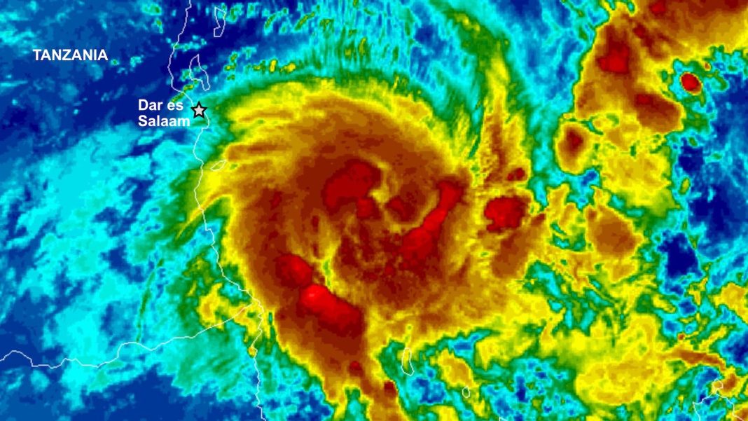
After suffering at least 155 deaths since March from disastrous floods, Tanzania is bracing for the approach of what could be the strongest tropical cyclone to affect the region in modern recordkeeping, with torrential rains in excess of 10 inches (254 mm) likely along its path.
As of 8 a.m. EDT Friday (12 UTC), the Joint Typhoon Warning Center placed the center of Tropical Cyclone Hidaya about 210 miles east-southeast of Dar es Salaam, the capital and largest city of Tanzania. Top sustained winds were 85 mph, making Hidaya the equivalent of a Category 1 hurricane.
Hidaya was moving west at about 7 mph but is expected to gain speed and angle slightly north of west, which would bring it onshore just south of Dar es Salaam on Saturday night local time. As it approaches the coast, Hidaya will be traversing very warm sea surface temperatures of around 30°C (86°F), around 1°C (1.8°F) above average. Fortunately, deep ocean heat content will be relatively low along Hidaya’s path, and dry air and moderate wind shear are expected to rapidly weaken the storm as it approaches the coast. Even so, given its potency early Friday, Hidaya could still be at tropical storm strength when it makes landfall.
Heavy rains from Hidaya threaten to exacerbate what is already the planet’s deadliest weather disaster of 2024: Exceptionally heavy rains during the April portion of the annual spring rainy season in Kenya, Tanzania, and Somalia, which have triggered floods that have left 476 people dead or missing. The death toll is the highest in Kenya, with 181 dead and 91 missing. An additional 42 people died there when a dam burst on April 29. The April flood death toll is 155 in Tanzania, and seven in Somalia. In the Conversation, a hydrology consultant says that the floods “expose decades of poor urban planning and bad land management” in Kenya.
As discussed in our January post, Africa has suffered an unprecedented number of deadly weather-related disasters over the past two years; an astonishing 23% of the continent’s 30 deadliest weather-related disasters since 1900 have occurred in the past two years. All of these disasters killed over 500 people, with climate change found to be a contributing factor in four of the ones from 2021-2023.
An uncommonly strong cyclone for its location
The NOAA Historical Hurricanes Tracks website shows that close to a dozen named storms have been recorded within a 235-mile radius of Dar es Salaam (including all of the Tanzania coastline), going back as far as an unnamed system in 1952. However, none of the systems within that radius were analyzed with top sustained winds any higher than 40 mph (minimal tropical-storm strength), and most were tropical depressions, as shown in Figure 1 below. So Hidaya is not only packing unprecedented strength for its track, but it has a legitimate chance of becoming Tanzania’s strongest tropical cyclone landfall in modern records. (Update: Eye on the Storm reader Ryan1000 points us to a 1984 National Weather Digest article on the 1952 storm. It includes a ship report of a 958-mb pressure from this storm when it was about 50 miles east of Tanzania, which would imply that winds were potentially above hurricane strength as it approached the coast.)
Tropical cyclones are rare near Tanzania because is it so close to the equator (Hidaya was located at 8.2°S at 8 a.m. EDT Friday).
The most recent tropical cyclone to make landfall in Tanzania was Tropical Cyclone Jobo, which peaked as a mid-strength tropical storm well offshore and made landfall as a tropical depression about 100 miles south of Dar es Salaam on April 24, 2021, leading to 22 deaths in Tanzania. As for that unnamed 1952 tropical storm, it made landfall at minimal strength, with top sustained winds of 40 mph.

A landscape primed for flooding after months of moisture enhanced by El Niño
Tanzania is near the end of its longer wet season, which typically runs from March into May. The shorter of the two annual wet seasons runs from October to December, and its rains are typically intensified during El Niño events, which was the case in 2023. Floodlist reported at least 89 flood-related fatalities in Tanzania from October into early December. The impacts have been even worse and have expanded into broader parts of East Africa during the longer wet season of 2024.
The heaviest rains and worst impacts from Hidaya will likely be confined to an east-west corridor across southern Tanzania and northern Mozambique, south of Dar es Salaam. Unfortunately, this may coincide with one of the areas hardest hit by recent rains and floods: the Rufiji district, where tens of thousands of people are reportedly in need of food, shelter, water, and health care. Hidaya is embedded in a rich field of deep atmospheric moisture, and it could produce rains in excess of 10 inches (254 mm) near the coast.


Hidaya is arriving near the end of a less-active-than-usual year for tropical cyclones across the Southern Hemisphere. According to the real-time statistics site at Colorado State University, accumulated cyclone energy for the climatological year thus far (July 1 – May 2) was roughly 75% of the 1991-2020 average in both the South Indian and South Pacific basins.
The Southern Hemisphere’s strongest tropical cyclone of the 2023-24 year to date has been Djoungou, which peaked in the remote South Indian Ocean as a Category 4 equivalent with top 1-minute sustained winds of 130 mph.
We help millions of people understand climate change and what to do about it. Help us reach even more people like you.


