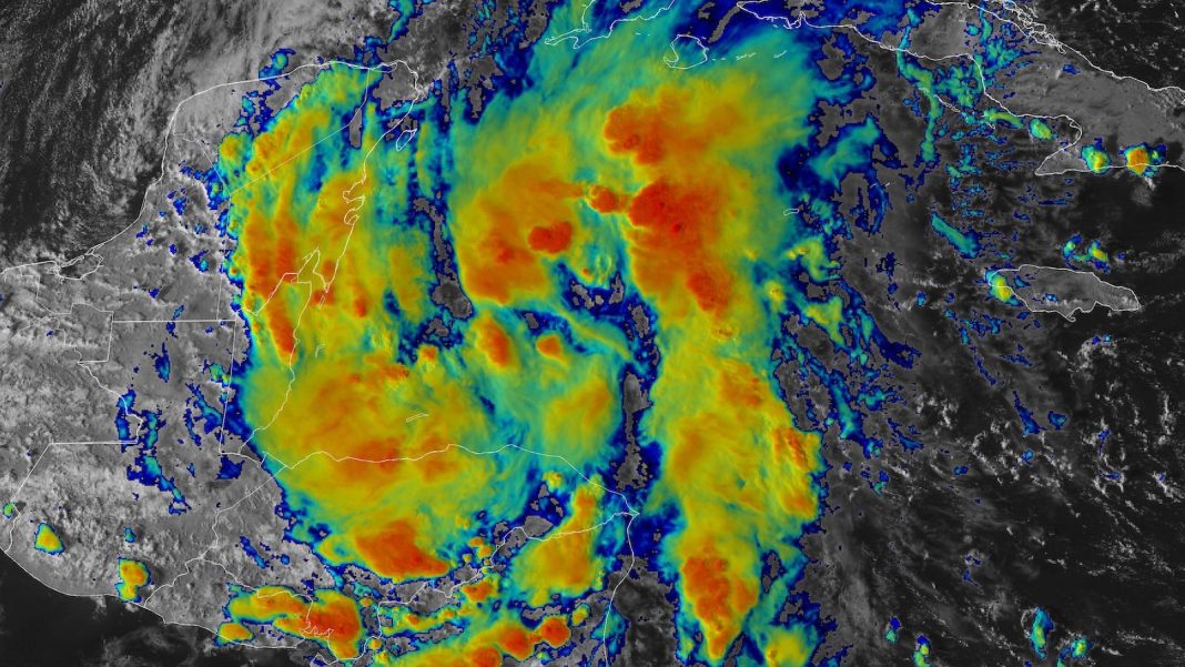
Bucking the odds during a quiet spell in the Atlantic, a sprawling disturbance east of Belize in the Northwest Caribbean was designated Potential Tropical Cyclone 15 (PTC 15) by the National Hurricane Center (NHC) at 5 p.m. EDT Friday, October 18. PTC 15 had a brief window to potentially strengthen into Tropical Storm Nadine before it moves westward into Belize and far southeastern Mexico on Saturday. On average, the 14th Atlantic named storm forms on November 19. Update: At 2 a.m. EDT Saturday, PTC 15 became Tropical Storm Nadine, with top sustained winds of 40 mph. Nadine was centered about 120 miles east of Belize City, moving west at 8 mph.
As of 5 p.m. EDT, the diffuse center of PTC 15 was about 210 miles east of Belize City, heading west-northwest at 7 mph (11 km/h). Top sustained winds were 35 mph (55 km/h). Showers and thunderstorms (convection) remained disorganized but were expanding across the Northwest Caribbean, with some hints of banding around a broad low-level circulation. Conditions favor some limited development in the short period of roughly a day before PTC 15 moves inland. The system was swaddled in a very moist atmosphere (mid-level relative humidity around 75%) and was moving over very warm sea surface temperatures around 30 degrees Celsius (86°F) with ample deep oceanic heat, all amid light to moderate wind shear of 5-10 knots.
Four high-resolution intensity models used by NOAA – the HWRF, HMON, HAFS-A, and HAFS-B models – were in agreement on Friday morning in making PTC 15 a low-end to mid-range tropical storm, with top sustained winds reaching between 40 and 60 mph before a projected landfall between 8 a.m. and 2 p.m. EDT Saturday. The SHIPS rapid intensification model from Friday morning gave PTC 15 a 44% chance of attaining top sustained winds of around 65 mph (105 km/h) by Saturday morning, with a 28% chance of reaching 70 mph (115 km/h). The official NHC forecast issued at 5 p.m. EDT Friday was a bit more conservative, predicting that PTC 15 would be a minimal tropical storm (top sustained winds of around 40 mph or 65 km/h) just before a projected landfall early Saturday afternoon along the northern coast of Belize. A reconnaissance flight into PTC 15 is scheduled for Saturday morning. After landfall, steering currents will keep PTC 15 heading westward toward a quick inland dissipation.
Whatever its status, this disturbance promises to dump pockets of torrential rain from northern Belize and Guatemala across far southern and eastern Mexico, with totals perhaps exceeding 12 inches in some locations and raising the threat of localized flooding.
An area of low pressure is forming east of the Yucatan Peninsula, and the NHC has initiated advisories on it as “Potential Tropical Cyclone 15” (#PTC15), which means the system is not yet a tropical storm but is expected to become one soon and impact land.
A strong ridge to the… pic.twitter.com/YgV4NnSmJB
— Dr. Levi Cowan (@TropicalTidbits) October 18, 2024
Invest 94L heads toward Hispaniola and the Bahamas
Another Atlantic disturbance, this one dubbed 94L, remained disorganized on Friday afternoon as it pushed westward just north of Puerto Rico. 94L was in a considerably drier environment than PTC 15, with mid-level relative humidity only around 45%, but strong convection was persistently bubbling around an emerging mid-level center of circulation. 94L was also bringing a moderate risk of rip currents to the northern coast of Puerto Rico.

Very warm sea surface temperatures of 30-31°C (86-88°F) and deep oceanic heat content would favor development, as would light wind shear of around 5 knots through Saturday, increasing to around 10 knots by Sunday. 94L’s track well north of the Greater Antilles will help reduce land interaction.
By the time 94L moves into a zone of much stronger wind shear on Sunday and Monday, any development should be quashed. Before then, it’s not inconceivable that 94L could become a short-lived tropical depression or tropical storm. However, only the European model was lending any support to that prospect on Friday. The odds of 94L’s development were pegged by NHC at just 20% in the 2- and 7-day period in its Tropical Weather Outlook issued at 2 p.m. EDT Friday. The next name on the 2024 Atlantic list after Nadine is Oscar. Update: As of 2 a.m. EDT Saturday, 94L’s development odds had been increased to 30%, but the system was still characterized as a trough of low pressure without a defined low-level center.


