[Haz clic aquí para leer en español]
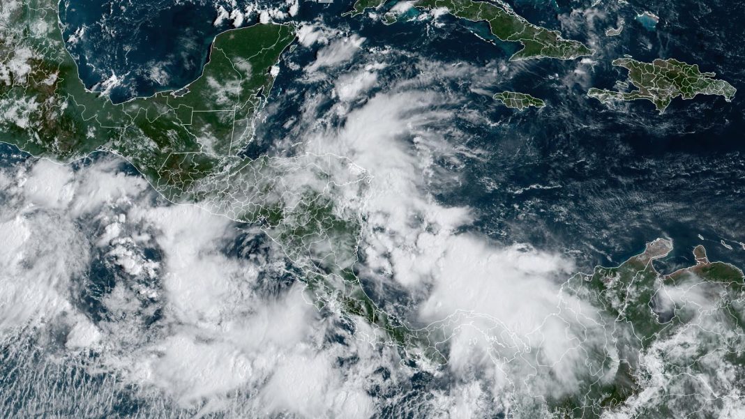
A sprawling low-pressure system known as a Central American Gyre is developing over Central America and will bring heavy rains to much of Central America and southern Mexico over the next week. The Central American Gyre is likely to bring seven-day rainfall amounts in excess of a foot (305 mm) to Pacific-facing coasts of Mexico, Guatemala, El Salvador, Honduras, and Nicaragua, causing life-threatening flash flooding and mudslides (Fig. 1).

The gyre — a type of monsoon low — is a weak but expansive area of surface low pressure that can persist for two weeks or more across Central America and adjacent parts of the Atlantic and Pacific, including the western Caribbean and southwest Gulf of Mexico. They are most common in May, June, September, October, and November. The gyres often spin off smaller circulations that can become full-fledged tropical cyclones. One such circulation formed in June in the Gulf of Mexico and became the season’s first named storm, Alberto.


A Central American Gyre typically takes many days to organize, then once fully developed, several more days to spin off a tropical cyclone. The formation location of a tropical cyclone spun off from a Central American Gyre is very difficult to predict more than two days in advance, but our top forecast models have been persistently predicting that it will spawn the Atlantic’s next named storm – Helene – sometime during the last week of September.
The models are not likely to converge on a likely location and timing for the formation of a potential Tropical Storm Helene for many days yet. The European model and its ensemble members favor a weaker and slower-developing storm over the southwestern Gulf of Mexico; the GFS model and its ensemble members favor a stronger storm farther to the east over the central Gulf. Both forecast camps have trended slower and farther westward with development since Thursday’s runs.


In its 8 a.m. EDT Friday Tropical Weather Outlook, the National Hurricane Center gave two-day and seven-day odds of tropical cyclone development in the Western Caribbean or southern Gulf of Mexico of 0% and 40%, respectively. As of Friday, no Hurricane Hunter missions for this system had been scheduled. With record to near-record ocean temperatures and oceanic heat content in the Gulf of Mexico, the ceiling for any storm that might get loose in the Gulf is a high one, and residents all along the Gulf Coast should anticipate the possibility that a hurricane may form in the Gulf during the last week of September.
Two systems in the open Atlantic unlikely to develop
Two disturbances in the remote subtropical Atlantic pose no threat to land areas in the foreseeable future, if ever. Both systems were given paltry two- and seven-day development odds of 20% by the National Hurricane Center in its 8 a.m. EDT Friday Tropical Weather Outlook.
The remnants of former Tropical Storm Gordon continue to fester about halfway between the Lesser Antilles and the Azores. Strong westerly wind shear of around 25 knots is keeping the showers and thunderstorms (convection) displaced toward the east of ex-Gordon’s weak surface low (1008 mb). The shear is predicted to abate this weekend, and the surface waters are unusually warm (around 28 degrees Celsius or 82°F), but the atmosphere is quite dry (midlevel relative humidity around 45-50%). Still, ex-Gordon might manage to regain its tropical storm status briefly as it drifts northward.


A few hundred miles to the west of Gordon, a disturbance named Invest 96L with a 1007-mb surface low is over similarly toasty subtropical waters and experiencing a bit less shear than ex-Gordon. Here too, though, the atmosphere is quite dry (midlevel humidity around 40-45%, and convection is limited, so any development would be gradual.
As of Friday morning, September 20, the only named tropical cyclone in the entire Northern Hemisphere was Pulasan, which was recurving northeastward over the South China Sea as a tropical depression after having made landfall near Shanghai on Thursday as a weak tropical storm. All four basins of the Northern Hemisphere – Atlantic, Northeast Pacific, Northwest Pacific, and North Indian – are now running below average for accumulated cyclone energy, or ACE, during this oddly tranquil peak season. This year’s hemispheric ACE of 212.7, as calculated by Colorado State University, compares to an average through September 20 (1991-2020) of 364.4. The global totals to date are 31 for named storms (average to date 41.4) and 15 for hurricane-strength storms (average 22.1).
We help millions of people understand climate change and what to do about it. Help us reach even more people like you.


