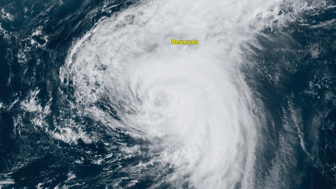
Hurricane warning flags are flying on Bermuda for the expected arrival of Ernesto as the Category 2 storm rumbles across the western Atlantic toward a close pass or direct hit on the island expected to occur early Saturday morning.
At 11 a.m. EDT Friday, Ernesto was a Category 2 storm with 100 mph winds and a central pressure of 970 mb, centered about 215 miles south-southwest of Bermuda, moving north-northeast at 14 mph. Satellite imagery showed a large hurricane, but high wind shear of 20-30 knots, caused by strong upper-level winds out of the west, had eroded away much of Ernesto’s heavy thunderstorms on the west side of its center.
Ernesto moved through the U.S. and British Virgin Islands on Tuesday night as a strong tropical storm, bringing torrential rains and wind gusts near hurricane strength to much of the Leeward Islands, Virgin Islands, and eastern Puerto Rico. The storm knocked out power to about half of Puerto Rico’s 2 million customers and dumped five to 10 inches of rain over about half of the island, causing flash flooding.
Ernesto’s big waves
Ernesto is a large storm with tropical storm-force winds that extend out up to 275 miles from the center and hurricane-force winds that extend out 75 miles. This large wind field is generating some big waves, causing dangerous swimming conditions at beaches along most of the Atlantic shore of the U.S. and Canada. Rip currents extend southward into the Bahamas as well as Puerto Rico, where heavy rains from Ernesto’s southern fringes persisted well beyond the storm’s passage.
Intensity forecast for Ernesto: Cat 1 likely for Bermuda
As Ernesto approaches Bermuda, it will continue tracking over near-record-warm sea surface temperatures of about 29 degrees Celsius (84 degrees Fahrenheit), which is roughly 0.5 degree Celsius (0.9°F) above average for mid-August. According to the Climate Shift Index tool for ocean temperatures from Climate Central, ocean temperatures this warm were made about 60 times more likely by human-caused climate change. However, wind shear is predicted to be moderate to high, and Ernesto will be in an environment with dry air, so weakening can be expected. The National Hurricane Center predicts that Ernesto will gradually weaken over the next day or so, most likely arriving in Bermuda early Saturday at Category 1 strength.
It will be a stormy Friday night and Saturday morning in Bermuda. The NHC forecast reflects close agreement among track models in bringing Ernesto very close to Bermuda, perhaps passing directly over or just west of the island. Given Ernesto’s size, gale-force (tropical-storm-force) sustained winds of 40 to 70 mph will lash Bermuda for close to 24 hours; hurricane-force sustained winds of 74 mph, with higher gusts, could affect the island for several hours early Saturday. Widespread rains of eight to 12 inches could peak locally at 15 or more inches, and the south side of the island will be hammered by significant storm surge and battering waves. The Bermuda Weather Service is warning of “confused and dangerous seas,” with waves peaking at five to 9 feet within the reef ringing the island and 25-35 feet outside the reef.
Up next: Newfoundland
A trough of low pressure passing to Ernesto’s north is expected to turn the hurricane more to the northeast early next week, and the storm is likely to pass near or over southeastern Newfoundland, Canada, on Monday night, when it will likely have transitioned to a powerful extratropical storm with 60-80 mph winds. Ex-Ernesto will then go on to bring heavy rains and high winds to Western Europe on Thursday.
Bermuda’s hurricane history
As detailed in Michael Lowry’s Substack feed, a Category 2 or stronger hurricane passes within 25 miles of Bermuda about once every 10 to 12 years, usually in September or October. The last Category 2 or stronger hurricane to hit Bermuda was Cat 2 Hurricane Paulette, whose eye moved over the northeastern portion of the on September 14, 2020, knocking out power to the entire island. However, only minor damage was reported on Bermuda, which may be the most hurricane-hardened place in the entire Atlantic. It has been over 20 years (since Fabian in 2003) that a hurricane-related death has been reported in Bermuda.

All quiet after Ernesto
The third week of August is typically the beginning of the most active portion of Atlantic hurricane season. But despite record-warm waters and an upper-level wind pattern with low wind shear predicted to set up over the tropical Atlantic over the next 10 days, forecast models are predicting little tropical cyclone activity. This appears to be occurring primarily because the tropical waves pushing off Africa that act as the seeds for hurricanes are emerging at a higher latitude than usual. Tropical waves emerging so far to the north encounter dry air from the Saharan Air Layer, limiting development chances.
Ampil makes an unsettlingly close swing near Tokyo
Powerful Typhoon Ampil was beginning a long-anticipated turn toward the northeast early Saturday local time that will spare southeastern Japan – including Tokyo, the world’s largest city – from what could have been a disastrous landfall. Ampil was located about 105 miles southeast of Tokyo’s Narita Airport at 11 a.m. EDT Friday, according to the Joint Typhoon Warning Center, with top sustained winds of 120 mph making Ampil the equivalent of a Category 3 hurricane. Torrential rains and strong winds from Ampil’s outer edge were raking southeastern parts of the island of Honshu, including the eastern and southern outskirts of Tokyo.
We help millions of people understand climate change and what to do about it. Help us reach even more people like you.


