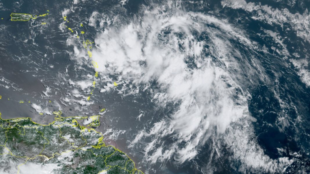
Tropical Storm Warning flags were flying from Guadeloupe to Puerto Rico on Monday in advance of Potential Tropical Cyclone 5. Racing across the western tropical Atlantic, but not yet well organized, this disturbance was predicted to pass through the northern Leeward Islands on Tuesday and over or near Puerto Rico and the Virgin Islands by early Wednesday as a strengthening Tropical Storm Ernesto. By late week, the future Ernesto is likely to be an intensifying hurricane that could threaten Bermuda and perhaps even the Maritime Provinces of far southeast Canada.
As of 11 a.m. EDT Monday, PTC 5 was a large but disorganized tropical wave, with extensive showers and thunderstorms (convection) but without the organized central circulation needed to qualify as a tropical depression. Top sustained winds were estimated at 35 mph, and PTC 5 was located about 435 miles east-southeast of Antigua, moving just north of due west at a brisk 26 mph. By early afternoon Monday, convection was starting to bubble around a potential low-level center. If this trend continues, PTC 5 may be a tropical depression or tropical storm as soon as Monday evening.
Forecast for PTC 5 / Ernesto-to-be
Once the convection around PTC 5 manages to consolidate around a focused center, conditions are favorable for development throughout this week. Wind shear should remain light to moderate (mostly 5-10 knots) through midweek, and the system is embedded in a fairly moist atmosphere, with mid-level relative humidity around 65%. Large regions of drier air extend well to the north and east, and this could impede development at times, but it appears PTC 5 may be able to largely wall off that drying influence as it organizes and intensifies. Sea surface temperatures are close to 1 Celsius above average (2 degrees Fahrenheit) along PTC 5’s path over the next couple of days. Intensity models are in close agreement that PTC 5 will be Tropical Storm Ernesto by Tuesday, as reflected in the National Hurricane Center forecast.
Some uncertainty will persist in the details of Ernesto’s short-term motion until a low-level center consolidates, but there is high confidence on a general west-northwest track, steered by a strong Bermuda-Azores upper high. The future Ernesto is expected to track over the northern Leeward Islands on Tuesday and over or near Puerto Rico and/or the Virgin Islands on Tuesday night or early Wednesday. Along with gale-force winds that could bring down trees and limbs and cause power outages, the main threat will be torrential rains, with localized totals expected to top 6 inches across the northeast Leeward Islands and approach or exceed 10 inches in Puerto Rico, raising the risk of flash floods and mudslides.

Once it clears the islands, the system is expected to turn toward the north and accelerate across the open Northwest Atlantic during the latter part of the week, as it feels the influence of a broad upper-level trough of low pressure extending south from far eastern Canada. The official NHC forecast brings the system to hurricane strength by late Wednesday and up to Category 2 strength by Friday and Saturday, when it may pass close to Bermuda. As shown in Figure 1 above, there is close agreement among both operational and ensemble models on this projected northward track, and it appears the future Ernesto will remain well east of the United States. Far southeastern Canada might be affected in about a week.


Status check: Are we still due for a hyperactive Atlantic season?
Despite outlooks for a frenzied 2024 Atlantic hurricane season, the pace of named storms is now well behind that of such landmark years as 2005, when Tropical Storm Irene formed on August 7, and 2020, when Tropical Storm Josephine formed on August 13.
However, that doesn’t mean we’ve had a quiet season thus far by any means. The amount of accumulated cyclone energy in the Atlantic this year as of August 12 is roughly three times the average for the date (40.7 vs. 13.2). Of course, that’s mainly as a result of long-lived Category 5 Hurricane Beryl. The ratio may be even more skewed in a few days once we see how the future Ernesto plays out.
In their latest update, issued on August 6, forecasters at Colorado State University trimmed their forecast of named storms slightly, from 25 to 23, given that dry air largely choked off Atlantic development in mid-to late July. Even so, the group is still calling for a total of 12 hurricanes and 6 major hurricanes, with what they call higher-than-average confidence for an August forecast. That outcome would put 2024 among the busiest seasons on record.
Keep in mind that the 2005 season spawned 17 named storms after August 15, including 11 hurricanes and 5 major hurricanes. The 2020 season was also prolific after August 15, as it ginned up 19 named storms, 12 hurricanes, and seven major hurricanes. So if the past is any prologue, there’s still a great deal of hurricane season left to track – and to prepare for.
We help millions of people understand climate change and what to do about it. Help us reach even more people like you.


