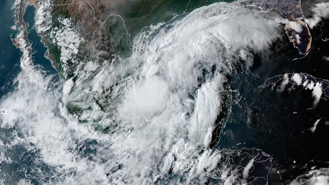
Tropical Storm Watches are up for the coast of Northeastern Mexico just south of the Texas border as a tropical disturbance located over the southwestern Gulf of Mexico’s Bay of Campeche heads toward an expected landfall near the Texas/Louisiana border on Wednesday. Further watches and warnings can be expected to be issued for portions of the Texas and Louisiana coast on Monday. The National Hurricane Center, or NHC, christened the disturbance Potential Tropical Cyclone 6, or PTC 6, at 5 p.m. EDT Sunday. The PTC designation is used for systems that could bring tropical storm or hurricane conditions to land areas within 48 hours but that are not yet tropical cyclones.
Latest National Hurricane Center advisory and forecast track. https://t.co/fFTgmQYBp4 #lawx pic.twitter.com/tu3eM5AbQs
— Rob Perillo (@robperillo) September 9, 2024
PTC 6 steadily growing more organized
At 8 p.m. EDT Sunday, PTC 6 was located 555 miles south of Port Arthur, Texas, moving northwest at 5 mph, with top sustained winds of 50 mph and a central pressure of 1003 mb. Satellite imagery showed that the disturbance had a modest-sized area of heavy thunderstorms with plenty of spin, which were steadily growing more organized. Conditions were very favorable for development, with record-warm ocean temperatures near 31 degrees Celsius (88°F), light wind shear of 5-10 knots, and a moist atmosphere.


A damaging storm surge possible in Louisiana
The coast of Louisiana is one of the most vulnerable locations in the world for high storm surges, because of the large expanse of shallow water offshore. A storm surge of about one foot was already being observed along much of the Louisiana coast on Sunday night, according to NOAA’s Tides & Currents website. Even if PTC 6 remains below hurricane strength, a storm surge of 3-5 feet is likely to the right of where the center makes landfall. If PTC 6 hits western Louisiana as a category 1 hurricane with 75 mph winds, as predicted by NHC in their 5 p.m. EDT Sunday forecast, the NOAA Water Prediction Service is predicting that it will bring a peak storm surge of 5-6 feet to central Louisiana, causing major coastal flooding.
High tide at Amerada Pass in central Louisiana is early Thursday morning at 3:30 a.m. EDT (7:30Z); low tide is Wednesday afternoon at 5:30 p.m. EDT (21:30Z). The difference in water level between high and low tide is about 1.5 feet, so the timing of PTC 6’s landfall will be a significant contributing factor in determining how much coastal flooding occurs. The 5 p.m. EDT Sunday NHC forecast called for a landfall near 3 p.m. EDT Wednesday, which would be near the time of low tide. However, we should expect the timing of landfall to change by six or more hours in future forecasts, since the system is still in the organizing stage and the models do not yet have a good handle on it.
With the formation of #Francine coming up, some models have some dry air trying to mix in with the system when it starts to potentially rapidly intensify, making it very lopsided in moisture. This could tamper with the strength a little all the way till landfall, in fact some… pic.twitter.com/mdpwFfKUNS
— StormHQ ☈ (@StormHQwx) September 8, 2024
I’ll have a detailed look at the forecast for PTC 6 in my early afternoon post on Monday, when it is likely to be Tropical Storm Francine.


