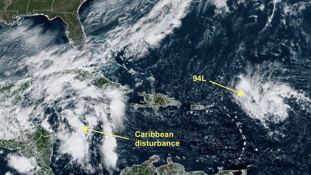
After an early October spate of intense activity, the tropical Atlantic has settled down, and we’re watching two tropical disturbances with just low odds of developing into a named storm. There’s a good possibility that Hurricane Milton will end up being the final named storm of October. However, with a pulse of the Madden-Julian Oscillation (MJO) due to arrive in the Atlantic in early November, which will favor rising air and increased odds of tropical cyclone formation, it’s still too early to close the book on the Atlantic hurricane season of 2024.

94L near the Leeward Islands
A Cabo Verde disturbance in the central Atlantic, dubbed Invest 94L, was approaching the northern Leeward Islands on Thursday as it sped westward at about 20 mph. Although the disturbance has light wind shear and record-warm ocean temperatures of 30 degrees Celsius (86°F) favoring development, 94L is embedded in a very dry air mass, which is keeping heavy thunderstorm activity limited, as seen on satellite loops. Development is also being hampered by its fast forward speed, which makes it difficult for 94L to align its upper-level center with its surface center. In addition, 94L is fighting against an unfavorable configuration of the Madden-Julian Oscillation (MJO), which favors sinking air over the Atlantic.
By Saturday, 94L will have two major impediments to development: a wall of hostile wind shear if it tries to move to the west-northwest toward Florida, or the imposing mountains of Hispaniola if the it moves more to the west-southwest over the Dominican Republic. Models are unenthusiastic about developing 94L, and generally predict its demise by Sunday. The disturbance maybe able to bring heavy rain showers dumping 1-2 inches (25-50 mm) of rain on the Leeward Islands, Virgin Islands, Puerto Rico, and the Dominican Republic, Friday through Saturday.
In its 8 a.m. EDT Thursday Tropical Weather Outlook, the National Hurricane Center gave 94L a 20% and 30% chance of development in the two- and seven-day periods, respectively. The next name on the Atlantic list is Nadine.
Torrential rains heading for parts of Belize and far southeast Mexico
A disturbance rotating around a Central American Gyre has only a slight chance of developing into a tropical cyclone before it pushes ashore this weekend, but it will dump dangerous amounts of rain regardless. This disturbance was centered on Thursday morning about 50 miles off the northeast coast of Honduras, drifting northwest with a central pressure of 1007 millibars and surrounded by a disorganized array of showers and thunderstorms. Ensemble models were in close agreement that the disturbance will move gradually west or west-northwest and come ashore along the Belize coast, or perhaps the Quintana Roo coast of Mexico, around Saturday.
This system is embedded in a relatively moist mid-level atmosphere, and it’ll be traversing sea surface temperatures of around 29-30 degrees Celsius (84-86°F), but that wall of strong upper-level winds noted above will be lurking just to its northwest, and it has only a limited amount of time to develop before moving inland. Only a few members of the GFS ensemble, and even fewer of the European ensemble, develop this system into a tropical depression or at best a weak tropical storm.
As of 8 a.m. EDT Thursday, the National Hurricane System gave the disturbance a 20% chance of development in the 2- and 7-day periods, with those odds mainly valid through Saturday before the system moves inland. Whatever its status, this disturbance promises to dump pockets of torrential rain from far southern and eastern Mexico to parts of Belize, Guatemala, and Honduras, perhaps exceeding 15-20” in some locations and raising the threat of mudslides and flash floods.


It’s cyclone season in the North Indian Ocean
The North Indian Ocean has two tropical cyclone seasons — one centered in May, before the onset of the monsoon, and one centered in October/November, after the monsoon has waned. During the June-September peak of the monsoon, tropical cyclones are uncommon because of interference from the monsoon circulation. With the monsoon now waning, the region’s fall cyclone season will likely be blooming next week, aided by a favorable phase of the Madden-Julian Oscillation (MJO) for the region. Multiple models are predicting a tropical cyclone will form in the eastern Bay of Bengal on Monday, then track northwestward or northward. The MJO will also favor typhoon development in the Western Pacific Ocean next week (see Tweet below).
A pulse of the Madden-Julian Oscillation may cause twin tropical cyclones to form in the West Pacific & Bay of Bengal next week! 🌀🌀
If the West Pacific storm forms & recurves into the North Pacific, it could affect the jet stream & U.S. weather patterns in early November. pic.twitter.com/TOy6j5DqyR
— Ben Noll (@BenNollWeather) October 17, 2024
The most recent major category 3 or stronger cyclone to make landfall on the Bay of Bengal coast was Cyclone Mocha, which hit Myanmar on May 14, 2023, as a category 4 storm with 155 mph winds, according to the Joint Typhoon Warning Center. Eight hours prior to landfall, at 0 UTC May 14, the Joint Typhoon Warning Center rated Mocha a category 5 storm with 175 mph winds, tying it with Cyclone Fani of May 2019 as the strongest tropical cyclone ever recorded in the North Indian Ocean. Mocha killed 151 people and did $2.3 billion in damage. Unfortunately, after a military coup in 2021 deposed the elected government, Myanmar has been fighting a disastrous civil war that has killed tens of thousands and displaced over a million people. Because of the war, the death toll from Mocha should be regarded as unreliable.
BREAKING: Cyclone #Mocha is making landfall in #Myanmar (near #Sittwe) with 1-min winds of 135 kts (250 km/h) in the US JTWC scale.
It ties with Cyclone Giri (2010) as the strongest landfalling tropical cyclone in Myanmar in recorded history, in terms of 1-min sustained winds. pic.twitter.com/aphjhKmHpU
— Matthew Cuyugan (@mscuyugan) May 14, 2023


