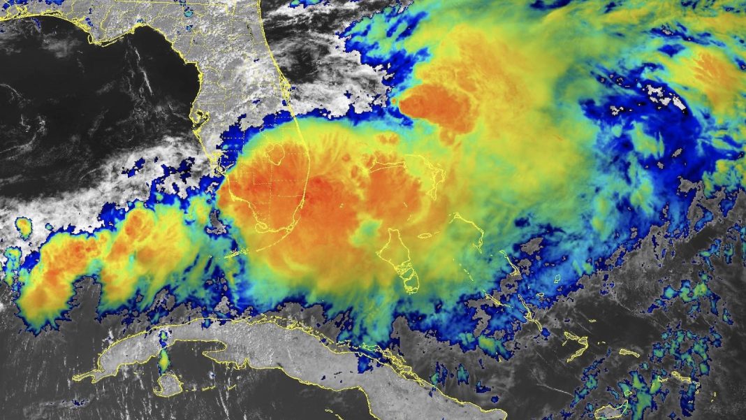
For a year that’s projected to rival the busiest on record, the Atlantic hurricane season 2024 has taken its time getting rolling. As of Wednesday, June 12, there had been no tropical cyclones recorded in either the Atlantic or Eastern Pacific. In the period since 1970 with reliable data for the Eastern Pacific, only two years — 1994 and 2009 — have made it as far as June 17 without at least one named storm somewhere in the Western Hemisphere, as noted by Phil Klotzbach at Colorado State University.
Things may get cooking this year before June 17, though. As of midday Wednesday, the National Hurricane Center, or NHC, was highlighting three areas of potential development over the next five days, including two in the Atlantic and one in the Eastern Pacific. Both systems in the Atlantic are positioned along a weak frontal zone stretching from the central Florida peninsula to the Bay of Campeche.
Invest 90L could become a tropical cyclone after drenching Florida
A parched May has abruptly segued into a soggy June across South Florida with the arrival of a Gulf of Mexico disturbance that’s been designated Invest 90L by NHC. The weak, poorly defined center of 90L rolled into northern Florida from the Gulf on Wednesday, with its circulation pulling rich tropical moisture onshore across the southern half of the state.
Surface pressures across Florida remained well above 1000 mb on Wednesday, and winds were generally light, but the juicy moisture was enough to dump prodigious rains without much atmospheric forcing. Widespread six- to 10-inch rains fell along and near the coast from the Tampa area south to the Everglades and northward to around Fort Lauderdale. Peak 24-hour totals on the CoCoRaHS volunteer observing site as of Wednesday morning included several nine- to 11-inch amounts near Sarasota, 5.8 inches south of Naples, and five to six inches in the Miami area.
Outlook for 90L
Once it moves off the Atlantic coast of Florida by late Wednesday, 90L will have at least some chance to briefly consolidate into a tropical depression or perhaps a weak tropical storm. Near-record sea surface temperatures for mid-June around 28 degrees Celsius (82 degrees Fahrenheit) will work in 90L’s favor, as will an increasingly moist midlevel atmosphere. What will likely keep 90L from developing is strong upper-level winds from the southwest, leading to high wind shear of 30-40 knots that will make it very difficult for any closed center to organize.
In its Tropical Weather Outlook issued at 2 p.m. EDT Wednesday, NHC gave 90L a 10% chance of becoming at least a tropical depression by Friday and a 20% chance through next Wednesday. Any development would most likely occur by this weekend and would pose little concern to the U.S. East Coast, aside from any winds and rains on its western fringe that might brush far eastern North Carolina.
Development possible in the Bay of Campeche
A somewhat better chance for the Atlantic’s first named storm of 2024 will take shape in the Bay of Campeche, where another disturbance is expected to form at the tail end of the frontal zone stretching from Florida across the Gulf. A broad circulation called a Central American Gyre — a common occurrence near the beginning and end of hurricane season — will be pulling ample moisture into the Gulf and providing some environmental spin.
A number of ensemble forecast members from the GFS and European models indicate that a surface low with pressures below 1,000 mb will likely spin off from the gyre in the Bay of Campeche (or the Northwest Caribbean initially) by early next week. Prevailing winds would push any such system westward toward a probable landfall along the northeast coast of Mexico later in the week. Heavy rains could extend well northward into the western U.S. Gulf Coast.
NHC called for a 30% chance of at least a tropical depression developing in the Bay of Campeche over the next seven days. The first name on the Atlantic list of 2024 is Alberto.
Farther south, another potential cyclone off southern Mexico
The same sprawling gyre that may lead to development in the Bay of Campeche might also spawn a tropical cyclone just to the south, off the coast of southern Mexico and western Guatemala. NHC gave this area a near-zero chance of development through Saturday but a 20% chance through next Wednesday. The first name on the Eastern Pacific list of 2024 is Aletta. Regardless of any tropical cyclone formation, models suggest that flow around the Central American Gyre will dump torrential rains along the higher coastal terrain of southern Mexico and western Guatemala over the next week-plus.
Drought-quenching rains hit the scene
The rains falling in Florida from 90L — and the rains predicted to fall in Mexico from next week’s tropical disturbances — would be more problematic if severe drought conditions were not present. Drought conditions in Florida early this week ranged from moderate to severe over much of the southern half of the state (Fig. 1 below). Mexico is suffering from its most severe drought since the fall of 2012, and severe to extreme drought conditions are present along most of the regions where heavy rains are expected to fall (Fig. 2).


We help millions of people understand climate change and what to do about it. Help us reach even more people like you.


